 Tweet
Tweet
.
Last update: March 08, 2022
NOTE:
(1) Do NOT install the dump1090-mutability on Pi24 img and Piaware img. Both these images already have their integral dump1090.
(2) TO HAVE A TROUBLE FREE INSTALLATION, IT IS REQUIRED TO MAKE A FRESH INSTALL, AS SHOWN BELOW:
It is important that first dump1090-mutability is installed, and data feeders are installed after dump1090-mutability has been installed.
1 - INSTALLATION
(A) RPi 2, 3, and 4 with Raspbian BUSTER and BULLSEYE
Package Install of dump1090-mutability (EB_VERSION) from repository.
(B) RPi 2 & 3 with Raspbian STRETCH
Package Install of dump1090-mutability_1.15~dev (pre-built package from Github)
2 - POST INSTALLATION CONFIGURATION
For most settings, accept default settings by pressing "Enter". At some screens, pressing "Enter" wont move screen to next step. In this situation, first press "Tab" key to turn "OK" button red on screen, hen press "Enter" key.
For following settings, enter values as shown:
(a) RTL-SDR dongle to use: 0
(b) Your receiver's Latitude (in decimal format): xx.xxxx
(c) Your receiver's Longitude (in decimal format): yy.yyyy
(d) Interface address to bind to (blank for all interfaces): remove default 127.0.0.1 and leave blank.
For advance users:Alternatively, you can change the settings by editing the configuration file shown below:
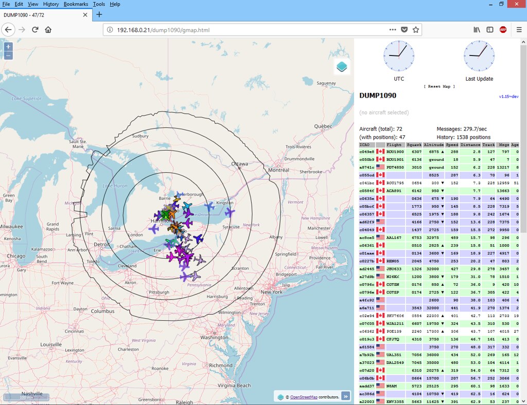
3 - OPTIONAL: ADD TERRAIN LIMIT RINGS
Dump1090-mutability v1.15~dev can display terrain limit rings using data obtained from the website http://www.heywhatsthat.com.[/FONT]
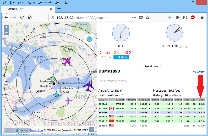
4 - VIEW MAP
To view map, type following address in your browser:
IP-of-RPi/dump1090/gmap.html
5 - TO CHANGE RANGE CIRCLES TO KMS
Range Circle by default are in nm (nautical miles).
To change to kms, issue following command:
Scroll down till you see following line:
Metric = false;
Change Metric=false to Metric = true;
Save file (Ctrl+O) and close it (Ctrl+x)
Reload browser (Ctrl+F5)
.
Last update: March 08, 2022
NOTE:
(1) Do NOT install the dump1090-mutability on Pi24 img and Piaware img. Both these images already have their integral dump1090.
(2) TO HAVE A TROUBLE FREE INSTALLATION, IT IS REQUIRED TO MAKE A FRESH INSTALL, AS SHOWN BELOW:
(a) Format microSD Card
(b) Write Raspbian Image.
(c) Install dump1090-mutability (Steps 1 to 5).
(d) Install data feeders FR24, Flightaware, & Planefinder (Steps 6, 7, & 8).
(b) Write Raspbian Image.
(c) Install dump1090-mutability (Steps 1 to 5).
(d) Install data feeders FR24, Flightaware, & Planefinder (Steps 6, 7, & 8).
It is important that first dump1090-mutability is installed, and data feeders are installed after dump1090-mutability has been installed.
1 - INSTALLATION
(A) RPi 2, 3, and 4 with Raspbian BUSTER and BULLSEYE
Package Install of dump1090-mutability (EB_VERSION) from repository.
Code:
sudo apt update
sudo apt install dump1090-mutability

sudo usermod -a -G plugdev dump1090
sudo systemctl restart dump1090-mutability
(B) RPi 2 & 3 with Raspbian STRETCH
Package Install of dump1090-mutability_1.15~dev (pre-built package from Github)
Code:
sudo bash -c "$(wget -O - https://raw.githubusercontent.com/abcd567a/dump1090/master/install_dump1090_mut_1.15.sh)"
2 - POST INSTALLATION CONFIGURATION
Code:
sudo dpkg-reconfigure dump1090-mutability

#After configuration is completed, restart dump1090-mutability
sudo systemctl restart dump1090-mutability
For following settings, enter values as shown:
(a) RTL-SDR dongle to use: 0
(b) Your receiver's Latitude (in decimal format): xx.xxxx
(c) Your receiver's Longitude (in decimal format): yy.yyyy
(d) Interface address to bind to (blank for all interfaces): remove default 127.0.0.1 and leave blank.
For advance users:Alternatively, you can change the settings by editing the configuration file shown below:
Code:
sudo nano /etc/default/dump1090-mutability
#after making changes, save file (Ctrl+o) and exit (Ctrl+x)

#Restart
sudo systemctl restart dump1090-mutability
3 - OPTIONAL: ADD TERRAIN LIMIT RINGS
Dump1090-mutability v1.15~dev can display terrain limit rings using data obtained from the website http://www.heywhatsthat.com.[/FONT]
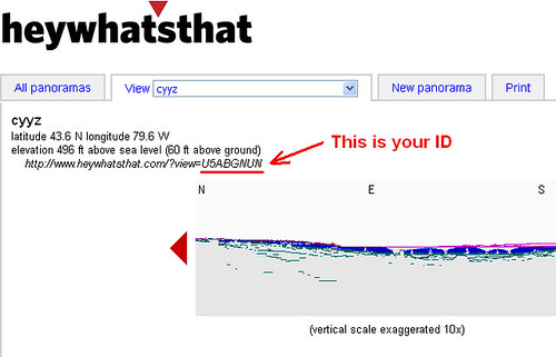
(a) First you have to generate a panorama for your location. To do this, follow the steps in first post of the following thread:
What is the Maximum Range I can Get?
(b) Once your panorama is generated, look near the top left of your newly created panorama page. You will see URL of your panorama there. The URL will be http://www.heywhatsthat.com/?view=XXXXXXXX where XXXXXXXX is the ID for your panorama.
See screenshot below.
(c) Use following command to download the generated panorama's JSON file "upintheair.json" to your RPi, and save it in the folder "/usr/share/dump1090-mutability/html"
(replace XXXXXXXX in the command below by your panorama's ID).
You can create as many rings as you want by adding elevations (in meters) at the end of URL given in the wget command above after "&alts=", separated by commas.
10,000 ft = 3048 m
20,000 ft = 6096 m
25,000 ft = 7620 m
30,000 ft = 9144 m
40,000 ft = 12192 m
Hence if you want to add all the 5 elevation rings noted above, the string at the end of wget URL will become "&alts=3048,6096,7620,9144,12192"
To keep map un-cluttered, I have used only 1 ring in the wget command above. i.e. the 40,000 feet (12192 meters).
Important:
Use altitude in meters in the wget URL above.
Do NOT use feet.
(d) RESTART dump1090-mutability
What is the Maximum Range I can Get?
(b) Once your panorama is generated, look near the top left of your newly created panorama page. You will see URL of your panorama there. The URL will be http://www.heywhatsthat.com/?view=XXXXXXXX where XXXXXXXX is the ID for your panorama.
See screenshot below.
(c) Use following command to download the generated panorama's JSON file "upintheair.json" to your RPi, and save it in the folder "/usr/share/dump1090-mutability/html"
(replace XXXXXXXX in the command below by your panorama's ID).
Code:
sudo wget -O /usr/share/dump1090-mutability/html/upintheair.json "http://www.heywhatsthat.com/api/upintheair.json?id=XXXXXXXX&refraction=0.25&alts=12192"
10,000 ft = 3048 m
20,000 ft = 6096 m
25,000 ft = 7620 m
30,000 ft = 9144 m
40,000 ft = 12192 m
Hence if you want to add all the 5 elevation rings noted above, the string at the end of wget URL will become "&alts=3048,6096,7620,9144,12192"
To keep map un-cluttered, I have used only 1 ring in the wget command above. i.e. the 40,000 feet (12192 meters).
Important:
Use altitude in meters in the wget URL above.
Do NOT use feet.
(d) RESTART dump1090-mutability
Code:
sudo /etc/init.d/dump1090-mutability restart
4 - VIEW MAP
To view map, type following address in your browser:
IP-of-RPi/dump1090/gmap.html
5 - TO CHANGE RANGE CIRCLES TO KMS
Range Circle by default are in nm (nautical miles).
To change to kms, issue following command:
Code:
sudo nano /usr/share/dump1090-mutability/html/config.js
Metric = false;
Change Metric=false to Metric = true;
Save file (Ctrl+O) and close it (Ctrl+x)
Reload browser (Ctrl+F5)
.


Comment