-
-
MH370 Tomnod discussion
Hi again,
my question is about tomnod- how exactly do you deliver them images you consider suspicion? I send it via FB, but may there is a more suitable way to do it?Comment
-
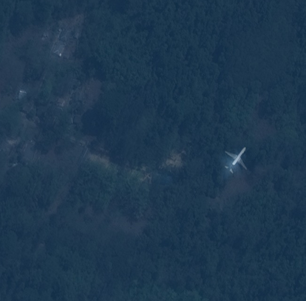
^^ tomnod is all over,.... and millions of guys are searching all across the Globe,..
and also a few even, have found some wrong/right planes too
and
it's a huge 'search overs' now a days. It seems, people will find 10s of other missing planes, lost decades ago.
Govt. perhaps already knows their locations,.... and for a reason, have not touched them, for getting its wreckage out.
You need to connect to some of these guys and forums rather, who seem to have a little bit of more, knowing about it.
http://www.abovetopsecret.com/forum/thread1002982/pg1


GLLast edited by voyager10; 2014-03-22, 20:43.Comment
-
Hello Julian,Originally posted by julian View Post
Sorry to say that there does not seem to be an e-mail facility in your personal detail section on this forum otherwise I would have contacted you with an explanation "off line".
However I will tell you how I do it. There may be easier ways but I am not that computer minded.
I click the "prtsc" key, go to accessories, click "paint" then "paste" followed by "Save". I can then send it to any place by e-mail or to a forum via the reply facility.
Hope this is quick/easy to follow way to do.
good luck
AlexComment
-
Debris.Part1.jpg
Debris.Part2.jpg
oil slick.jpg ????
I'll post some objects that caught my attention, hope you don't mind, anyone who has time to look at them, would appreciate it! the first one especially looks like the engine...
*** Update : adding other objects I saw, the first object is quite sharp from the look of it.
Debris.Part3.jpg
repeated one object by mistake cant seem to edit here and upload it again
this is the map I'm looking at: http://www.tomnod.com/nod/challenge/...ian_ocean/map/ (+ following each numbers according to the object posted) , I know there is a lot of scrap around it's been mentioned earlier in a previous post, really dont know how to add the latitude where is the option for that don't see it in chrome and puff and zooming it doesnt work with the mouse but have to use the chrome zooming tool.
continue to look further...Last edited by Angie33; 2014-03-22, 22:05.Comment
-
thank you!Comment
-
Those who are searching on tomnod,.. should always keep in mind these two maps.
'Coz otherwise you may find tons of scrap in the ocean and would be of no use.
1)
Open this world map first

and zoom the area of probability ( click with mouse button and mouse roller ) and you will see immediately,
that 70d E to 140d E the (vertical) lattitude lines and
20d N to 60d S the (horizontal) longitudinal lines ( Say, 10 degree North(up) of the equator line and about 60d-70d south(below) of the equator line )
this makes your searching region.
( Agree with me ? )
2)
If you will look at their, this picture,... ( recently, China gave it )
the
latitude and longitudes shown on this picture,.. IS and MUST follow in the above given possible range.
So,.. do not search on any Maps there, but define your grid range to search for, first.
..................Last edited by voyager10; 2014-03-22, 21:56.Comment
-
MH370 Tomnod discussion
Voyager 10 , so where could I find the option in Tomnod to see where the map is currently located because I dont see it...
plus there is no option to select an area to look, this came out automatically at the beginning of the page asking to help on the search. Only indicates that the map is based on the indian ocean.
this is the only thing i see on the right bottom side :
for example,
Your Current Location
Map 1944
no Latitude/Longitude
can Tomnod actually provide a map at an earlier date around 10th of March????Last edited by Angie33; 2014-03-22, 22:53.Comment
-
MH370 Tomnod discussion
Originally posted by Cambridge
How can it not be found, I've been using it for hours and almost finishing before I start the other map.
try this, let me know
found some solid objects , just finishing and then will go through each one and pick the object forms that could belong to an aircraft, not sure if they are 100% but its an attempt. I know in my earlier post I put some objects that didnt look very convincing though the first one does look similar to the engine.Last edited by Angie33; 2014-03-23, 00:20.Comment
-
solid objects , debris.part4 images
Debris.Part4.jpg
the last pic I kinda turned it 180 degrees around too focus more, anyway not much more could be found.
@Cambridge
How did you find the latitude and longitude????
Does anyone know if Tomnod has a map for the date 10/04/14 focusing on top of Indian Ocean until mid? Or possible option of choosing any particular area?
debris.p5.jpg
Probe into mystery call to captain of doomed jet: Unknown woman used a fake ID when buying phone to bypass security checks
Last edited by Angie33; 2014-03-23, 01:38.Comment
-
@Cambridge
Thanks for the info, regarding on what you mentioned about being funny, I honestly don't find anything funny in this but tragic, Tomnod has the guts of
leading me and god knows how many others towards this map that at the end was a complete failure in search wise and a waste of time. Feel like the time
is clicking it's two weeks and there are very little results, feel bad for the families and just like everyone else want to help though it might not be
a huge significance even a bit it's better than nothing,right?
Can you please give me the current map , the correct one and also is there an option to look in other areas if I wanted to look on land for example how can it be done?
@voyager10
The link was some news I saw and just pasted it like an update I guess, not assuming anything.
Right now keeping an open mind to every possibility...No conclusions yet.Last edited by Angie33; 2014-03-23, 03:40.Comment
-
I do not want to rain on your parade,... ( tomnod guys ), but I sincerely doubt, that the satellite pics are "running - live".
I, at least know about, how the Google map works.
They run the satellite hardly twice a year ( updates the gogle map twice a year ) when the trees and leaves are ( low - fall time) down, so you can see the tiny roads and driveways clearly.
In other words,… if you type your street address on map.google.com, the pic you are watching must be at least 4-6 months older, that's how the scene looked 5+ mos ago. I am positive about this.
I dunn’o tomnod, but still the common sense tells me, it just can not be as live as you are watching,..
so what ever you watch is, couple days older say,… and here is the draft of the ocean of south oceans,…( below link ) will give an idea how fast the stuff can move,
and before someone, really really searches on your located items ( by sending a real crew ) it would be at least 6-7 days old,.
And the object has moved at least couple hundreds mile away then where you are suggesting, where it should be !
So ? I guess, it’s just a fun game, so far I understand it.
This is how the south ocean draft remains,..
http://www.skyscrapercity.com/showpo...&postcount=151 ( screen : i-f member, pass: 123456 )Last edited by voyager10; 2014-03-23, 03:51.Comment
-
Hello,
Some posts back a clever chap had found a way to fix the Lat and Long of pics on Tomnod.
Note letters on two items.
Well I came across this today, perhaps if he/she is looking then please is this picture from the southern hemisphere ?
Thanks.
Alex
Letters.jpg
PS
I found the instructions, and changed "Challenge" to "api", the co-ordinates were roughly Latitude 07.5, Longitude 109.04 when placed on a map it turns out it is off the Vietnam coast in aprox the first area that was expected ????Last edited by Alex Smart; 2014-03-23, 08:05.Comment
-
MH370 Tomnod discussion
@Cambridge
can you please verify if this url of the new map given is in a correct place? I would appreciate it a lot!
this is what Tomnod twitter mentioned on the 21rst of March, but I noticed they have been changing maps, yesterday was a completely different one.
Tomnod @tomnod 21 de mar.
New #satellite images available on http://Tomnod.com . Search Maldives and East Indian Ocean #MH370
is there a way to get to the map of where the search area is now being focused on near perth?
I'm afraid I dont have a twitter neither a facebook account, dont use this type of social websites.Last edited by Angie33; 2014-03-23, 14:40.Comment
-
You can do that yourself: put 92504 in http://tomnodmaplocator.com/Originally posted by Angie33 View Post
There is no tomnod map west of Australia.is there a way to get to the map of where the search area is now being focused on near perth?
A humble request: please show some respect for the purpose of this forum and take your tomnod questions to the tomnod forum, please?Comment
- IMPORTANT NOTICE! Before you post on Flightradar24 forum you must read this important information about Flightradar24
 Tweet
Tweet


Copyright (c) 2009-2019 by Flightradar24
Powered by vBulletin®
All times are GMT. This page was generated at 20:24.
Working...
X
We process personal data about users of our site, through the use of cookies and other technologies, to deliver our services, personalize advertising, and to analyze site activity. We may share certain information about our users with our advertising and analytics partners. For additional details, refer to our Privacy Policy.
By clicking "I AGREE" below, you agree to our Privacy Policy and our personal data processing and cookie practices as described therein. You also acknowledge that this forum may be hosted outside your country and you consent to the collection, storage, and processing of your data in the country where this forum is hosted.
Comment