 Tweet
Tweet
I hear that among pilots the belief is that a heist of Gold Bullion is behind this mystery.
-
-
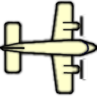
Yes, it's a RAF Sentinel R1 operated by the Royal Air Force. It's basically a standard Bombardier Global Express (GLEX) bizjet, indeed a quite proven airframe, with the addition a rather sophisticated AESA look-down radar mounted in a belly pannier, and a satellite link radome mounted on the upper fuselage. It's main use in Afghanistan is battlefield surveillance and time-sensitive targeting (to identify and engage fleeting ground targets) in support of the NATO ISAF operations.Originally posted by Flybywire View Post
The Ghazni province (above which the aircraft is seen circling) is currently one of the more volatile areas of Afghanistan, with frequent insurgency activity. Some senior Taliban militants were taken out a few weeks ago, contributing to the unrest among insurgents. The upcoming (April 5) presidential elections is another factor making the atmosphere a wee bit more tense.Comment
-
It's just a Pilot having fun doing sky donuts... you can't do that kind of stuff in US airspace LOL!Originally posted by winni View PostComment
-
Here read this,Originally posted by longpig_yum View Post
Also FlightRadar24 uses ADS-B which is not really a radar but a data-link from the Aircraft's flight management computer sending us once a second the flight's location, altitude, etc.
An object in the sky can be tracked by Primary Radar, even without a transponder or ADS-B, however you'll have no idea what it is or who it is. The radar cross-section will tell you the approximate size of the object, you can also determine the approximate speed it's traveling however altitude is hard to determine with just primary radar, and this is why aircraft have transponders, that send this information back to ATC along with an ID known as a squawk code as part of the SSR.Last edited by 1090 MHz; 2014-03-16, 00:04.Comment
-
What time that would be in New Zealand? At that altitude I believe it would have to be night time for him to see any kind of flame. I doubt he could distinguish between a jet and a falling star. I don't think he would see anything but the vapour trail during daylight hours.Originally posted by eisenhower View PostComment
-
I don't know. Like a computer you might need a code to reprogram it. But with all those Texas Tech experts onboard or seeing how carefully this was planned. It is very possible. Very worrying. I just hope the hijackers screw up somehow or someone lost their nerve.Originally posted by paf View PostComment
-
This is a link to the list of airfields in Kazakhstan. Spooky.... these are the kinds of questions that were being asked two years ago...
"Does anyone know if there are NDB's, VOR's, ILS's or communication radio frequencies associated with Krayniy? I would like to compile as much complete information about this airport as possible so that I can create a scenery package for X-Plane. Other information that would be useful: Runway approach lighting type, and runway edge lights. Also, I have seen references to an ICAO code of UAOL for this airport. Can this be verified?"Comment
-
OK, Now it's starting to make sense. Malaysias military were caught with their pants down.
Now they supposedly have a Primary radar track showing an Unidentified plane heading west
towards the andamans. This data having been retrieved from the logs, and not observed live.
This is what I have been wondering. Surely there had to be 'passive' primary radar operating
at one or more installations that would have tracked the plane. An unidentified plane would surely
have set off some sort of alert, but only if anyone was awake to notice it.Comment
-
Re: Tomnod.com
I think this is a great tool to have people help search. However, we had no idea the areas we are searching... Until now... It now shows on the map the areas that had been given to us to search, and of the tags that I see on this map (screenshot below) These are some areas that are not even close to where the plane would have possibly been even if it had stayed on its scheduled course and not turned west. For example, there were 120 objects tagged just Southwest of Kuala Lumpur where the plane took off. Why would they have us search those maps?
Anyway, with the new evidence, it seem the plane is most likely in the Indian ocean if it crashed. I wonder why they do not have maps of that area to search now. So, at this point, it seems that it won't do much good to look on the tomnod site.
I did search a lot on there early on, when I could get on the site... almost 4000 maps... And even though it was nice to actually see something once in a while, like a ship or oil rig, I know that there would not be debris from the plane in that area because the people on the oil rigs and ships in that area would have spotted it before we have.
If they could have somehow taken into account, known ship, oil rigs, and populated coastal area positions into account at the time the satellite photo was taken, they could have limited the search area for us, by not having us search those areas.
Anyway, I am not against the site and what they do to try to have us help in a case like this. I think it could be a very useful tool with some more work.tomnod.jpgComment
-
Hello Cambridge,
No thought as to how the captors would care for the hostages - feed and shelter them after arrival at the so far unnamed destination ?
I hope that if the authorities are planning a hostage rescue that the arrange to take a McDonald's and KFC with them, as the poor passengers would by now be quite hungry and thirsty don't you think ?
However I expect that if they had been taken hostage we would have heard from their captors by now with ransom demands or such ?
AlexComment
-
Originally posted by Sea Petal View Post
Not sure what New Zealand time has to do with anything - the oil rig was based out in the sea off the Malaysian Coast - and it was by chance a New Zealand worker who's working there
Comment
-
On the main website for tomnod.com if you scroll down, it will show you the current search results, with a map and locations that have been searched and tagged. You can zoom in and see what has been tagged so far.Originally posted by CambridgeComment
-
What interests me is that the Malaysian air force where the only ones to pick up the primary track. Across Malaysia there are a number of civil radars that should also have a primary track. That data is usually recorded. Where is it?Originally posted by iazoniccc View PostComment
-
No. Each ADS-B transmits a unique aircraft 'frame code' which cannot be changed.Originally posted by paf View PostComment
-
If this was a successful hijack and if the authorities were able to determine that the plane did not crash then i'll bet that there will be no useful public announcements (or have even more confusing decoys) in the next few days as authorities plot their rescue mission. I hope if this is the case that it is NOT the Malaysian authorities who is doing the plotting. Please put national pride aside and have EXPERTS do this.Comment


Comment